Skip to main content Skip to main navigation
heart-solid My Visit Donate
Home Smithsonian Institution IK development site for ODI
Press Enter to activate a submenu, down arrow to access the items and Escape to close the submenu.
    • Overview
    • Museums and Zoo
    • Entry and Guidelines
    • Museum Maps
    • Dine and Shop
    • Accessibility
    • Visiting with Kids
    • Group Visits
    • Overview
    • Exhibitions
    • Online Events
    • All Events
    • IMAX & Planetarium
    • Overview
    • Topics
    • Collections
    • Research Resources
    • Stories
    • Podcasts
    • Overview
    • For Caregivers
    • For Educators
    • For Students
    • For Academics
    • For Lifelong Learners
    • Overview
    • Become a Member
    • Renew Membership
    • Make a Gift
    • Volunteer
    • Overview
    • Our Organization
    • Our Leadership
    • Reports and Plans
    • Newsdesk
heart-solid My Visit Donate

Model, Sensor, Thematic Mapper, Landsat 4

Air and Space Museum

There are restrictions for re-using this image. For more information, visit the Smithsonian's Terms of Use page .
International media Interoperability Framework
IIIF provides researchers rich metadata and media viewing options for comparison of works across cultural heritage collections. Visit the IIIF page to learn more.
View manifest View in Mirador Viewer

    Object Details

    Manufacturer

    Santa Barbara Research Center

    Summary

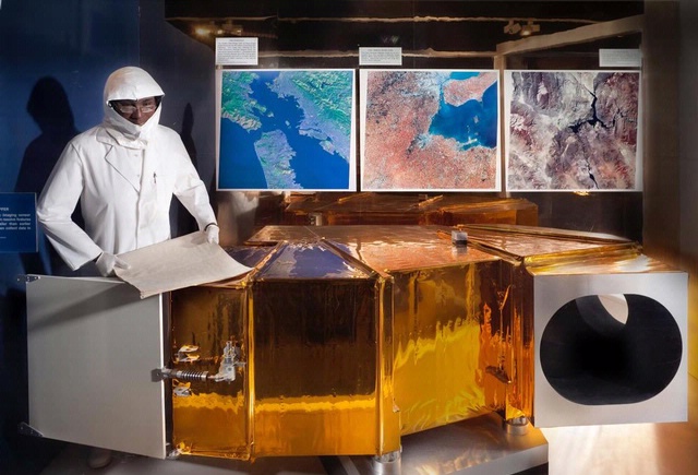
    In the 1970s NASA inaugurated the Landsat series of satellites to study the Earth's surface from space. The program demonstrated the practical benefits of space-based mapping and study of the Earth's natural resources continuously and on a global basis.
    This artifact is a full-scale model of the Thematic Mapper (TM) instrument first used on Landsat 4, which launched in 1982 and operated until 1993. As the instrument flew over the Earth it "saw" only selected wavelengths of light that, when processed, provided information on the condition of land, water, and vegetation. Compared to instruments on the first generation Landsat satellites, TM collected data in more wavelengths and with greater resolution. It worked in tandem with the satellite's other major instrument, the Multi-Spectral Scanner (MSS), providing a greatly improved range and quality of data on Earth resources.
    The Santa Barbara Research Center donated the model to the Museum in 1985.

    Credit Line

    Gift of Santa Barbara Research Center, Hughes Aircraft Co.

    Inventory Number

    A19850789000

    Restrictions & Rights

    Usage conditions apply

    Type

    MODELS-Uncrewed Spacecraft & Parts

    Materials

    Aluminum, plastic, mylar

    Dimensions

    Overall: 2 ft. 7 in. tall x 3 ft. 5 in. wide x 5 ft. 4 in. long (78.74 x 104.14 x 162.56cm). Weight: 326.6 kg (720 lbs).

    Country of Origin

    United States of America

    See more items in

    National Air and Space Museum Collection

    Data Source

    National Air and Space Museum

    Metadata Usage

    Not determined

    Link to Original Record

    http://n2t.net/ark:/65665/nv934a0adb7-ade2-43aa-ac4b-2b147b2afd92

    Record ID

    nasm_A19850789000

    Discover More

    Civilian Application Satellites Object Group

    Civilian Application Satellites

    Civilian Application Satellites Object Group

    Civilian Application Satellites

    arrow-up Back to top
    Home
    • Facebook facebook
    • Instagram instagram
    • LinkedIn linkedin
    • YouTube youtube

    • Contact Us
    • Get Involved
    • Shop Online
    • Job Opportunities
    • Equal Opportunity
    • Inspector General
    • Records Requests
    • Accessibility
    • Host Your Event
    • Press Room
    • Privacy
    • Terms of Use