Skip to main content Skip to main navigation
heart-solid My Visit Donate
Home Smithsonian Institution IK development site for ODI
Press Enter to activate a submenu, down arrow to access the items and Escape to close the submenu.
    • Overview
    • Museums and Zoo
    • Entry and Guidelines
    • Museum Maps
    • Dine and Shop
    • Accessibility
    • Visiting with Kids
    • Group Visits
    • Overview
    • Exhibitions
    • Online Events
    • All Events
    • IMAX & Planetarium
    • Overview
    • Topics
    • Collections
    • Research Resources
    • Stories
    • Podcasts
    • Overview
    • For Caregivers
    • For Educators
    • For Students
    • For Academics
    • For Lifelong Learners
    • Overview
    • Become a Member
    • Renew Membership
    • Make a Gift
    • Volunteer
    • Overview
    • Our Organization
    • Our Leadership
    • Reports and Plans
    • Newsdesk
heart-solid My Visit Donate

Model, Meteorological Satellite, Tiros N

Air and Space Museum

There are restrictions for re-using this image. For more information, visit the Smithsonian's Terms of Use page .
International media Interoperability Framework
IIIF provides researchers rich metadata and media viewing options for comparison of works across cultural heritage collections. Visit the IIIF page to learn more.
View manifest View in Mirador Viewer

    Object Details

    Manufacturer

    RCA Astro Electronics

    Summary

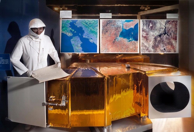
    First launched in 1978, the TIROS-N (Television Infrared Observation Satellite) series was the third generation of TIROS weather satellites--a program first begun in 1960.
    NASA developed the satellites then transferred them to the National Oceanic and Atmospheric Administration (NOAA) once in orbit and operational. The satellites flew in polar, sun synchronous orbits and gathered information on day and night cloud-top and sea surface temperatures as well as on water vapor in the atmosphere. The satellites also carried a data collection platform that received and processed information from balloons and buoys positioned worldwide.
    TIROS-N satellites worked in conjunction with another type of meteorological satellite, the Geostationary Operational Environmental Satellite (GOES), to provide comprehensive weather coverage of the Earth. The GOES satellites provided data on near-term weather conditions, the TIROS-N for longer-term forecasting.
    This artifact is a scale model of a TIROS-N spacecraft, donated by RCA to the Museum in 1984.

    Alternate Name

    Model, Meteorological Satellite, Tiros N

    Credit Line

    Donated by RCA AstroElectronics

    Inventory Number

    A19840661000

    Restrictions & Rights

    Usage conditions apply

    Type

    MODELS-Uncrewed Spacecraft & Parts

    Materials

    Plastic

    Dimensions

    Overall (satellite): 1 ft. 4 in. tall x 5 3/4 in. diameter x 1 ft. 7 in. wide (40.6 x 14.61 x 48.26cm)
    Other (solar panel): 1 ft. 7 in. long (48.3cm)

    Country of Origin

    United States of America

    See more items in

    National Air and Space Museum Collection

    Data Source

    National Air and Space Museum

    Metadata Usage

    Not determined

    Link to Original Record

    http://n2t.net/ark:/65665/nv90343ed67-a408-4b02-aa93-d034764459e0

    Record ID

    nasm_A19840661000

    Discover More

    Civilian Application Satellites Object Group

    Civilian Application Satellites

    Civilian Application Satellites Object Group

    Civilian Application Satellites

    arrow-up Back to top
    Home
    • Facebook facebook
    • Instagram instagram
    • LinkedIn linkedin
    • YouTube youtube

    • Contact Us
    • Get Involved
    • Shop Online
    • Job Opportunities
    • Equal Opportunity
    • Inspector General
    • Records Requests
    • Accessibility
    • Host Your Event
    • Press Room
    • Privacy
    • Terms of Use