Skip to main content Skip to main navigation
heart-solid My Visit Donate
Home Smithsonian Institution IK development site for ODI
Press Enter to activate a submenu, down arrow to access the items and Escape to close the submenu.
    • Overview
    • Museums and Zoo
    • Entry and Guidelines
    • Museum Maps
    • Dine and Shop
    • Accessibility
    • Visiting with Kids
    • Group Visits
    • Overview
    • Exhibitions
    • Online Events
    • All Events
    • IMAX & Planetarium
    • Overview
    • Topics
    • Collections
    • Research Resources
    • Stories
    • Podcasts
    • Overview
    • For Caregivers
    • For Educators
    • For Students
    • For Academics
    • For Lifelong Learners
    • Overview
    • Become a Member
    • Renew Membership
    • Make a Gift
    • Volunteer
    • Overview
    • Our Organization
    • Our Leadership
    • Reports and Plans
    • Newsdesk
heart-solid My Visit Donate
  1. Home
  2. forward-slash
  3. About
  4. forward-slash
  5. Newsdesk
  6. forward-slash
  7. Photos and Video
  8. forward-slash
  9. Mars - SHARAD Data

About

  • Overview
  • Our Organization
    • Board of Regents
    • Museums and Zoo
    • Research Centers
    • Cultural Centers
    • Education Centers
    • General Counsel
    • Office of Human Resources
    • Office of Equal Opportunity
    • Office of Sponsored Projects
    • Office of Protection Services
  • Our Leadership
  • Reports and Plans
    • Annual Reports
    • Strategic Plan
    • Smithsonian Dashboard
  • Newsdesk
    • News Releases
    • Media Contacts
    • Photos and Video
    • Media Kits
    • Fact Sheets
    • Visitor Stats
    • Secretary and Admin Bios
    • Filming Requests

Mars - SHARAD Data

Media Photo/Video

March 7, 2013

download Download 4605h.jpg
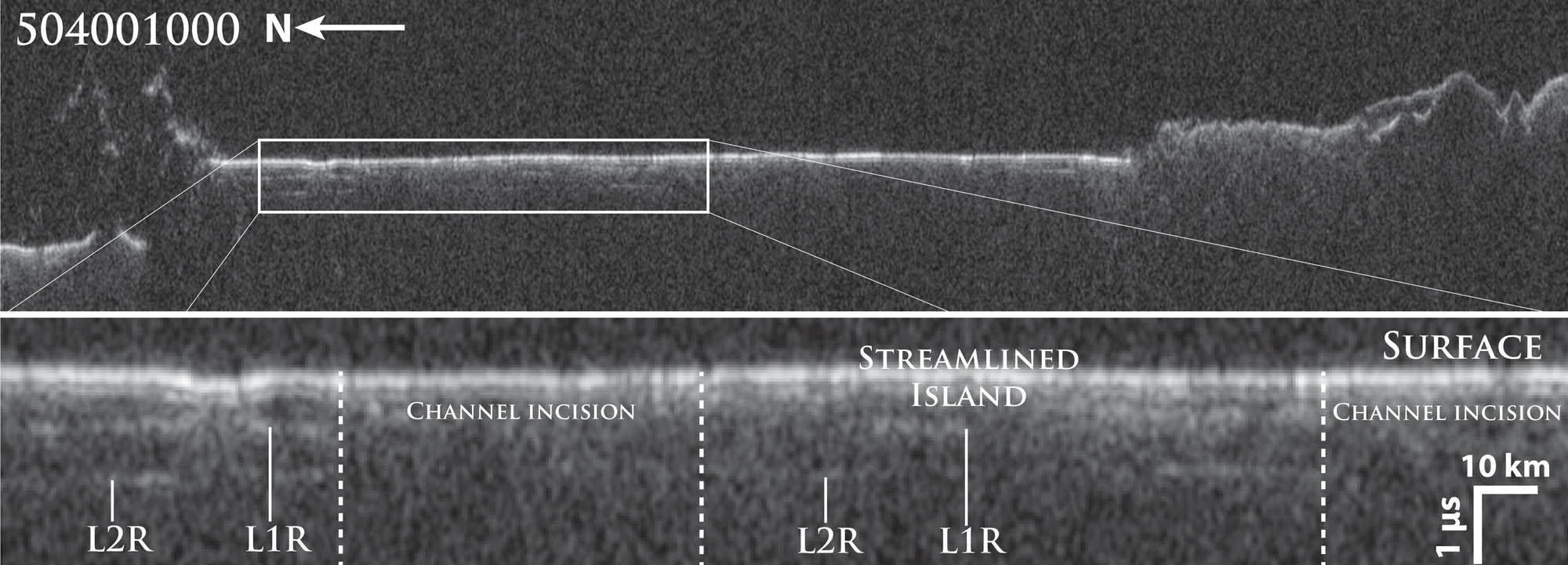
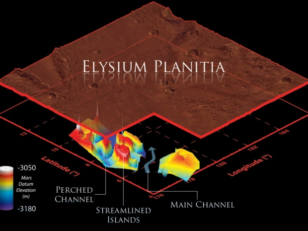
Example of SHARAD data used in the study. SHARAD data is presented as radargrams which depict the delay time of the return signal against distance along the martian surface. From this we can identify the surface and subsurface structure. Throughout eastern Elysium Planitia two parallel subsurface reflectors are present (L1R and L2R) which we interpret to be boundaries between extensive geologic layers. The formation of Marte Vallis cut channels through these boundaries. Thus from identifying where the reflectors are absent, we were able to map out the shape and scale of the Marte Vallis channels. Image Number: WEB12780-2013

Tags

  • Air and Space Museum

Related Media

Image

document

Mars - 3D visualization of buried Marte Vallis channels

03.07.2013

Image

document

Mars - Geologic history of Eastern Elysium Planitia

03.07.2013

Image

document

Mars - Marte Vallis channel system

03.07.2013

Related Content

  • New 3-D Reconstructions Show Buried Flood Channels on Mars

    New maps of the subsurface of Mars show for the first time buried channels below the surface of the red planet. Mars is considered to have been cold and dry over the past 2.5 billion years, but these channels suggest evidence of flooding.
    • March 7, 2013
    • News Release
    • Air and Space Museum
    • Air and Space Museum
arrow-up Back to top
Home
  • Facebook facebook
  • Instagram instagram
  • LinkedIn linkedin
  • YouTube youtube

  • Contact Us
  • Get Involved
  • Shop Online
  • Job Opportunities
  • Equal Opportunity
  • Inspector General
  • Records Requests
  • Accessibility
  • Host Your Event
  • Press Room
  • Privacy
  • Terms of Use