Skip to main content Skip to main navigation
heart-solid My Visit Donate
Home Smithsonian Institution IK development site for ODI
Press Enter to activate a submenu, down arrow to access the items and Escape to close the submenu.
    • Overview
    • Museums and Zoo
    • Entry and Guidelines
    • Museum Maps
    • Dine and Shop
    • Accessibility
    • Visiting with Kids
    • Group Visits
    • Overview
    • Exhibitions
    • Online Events
    • All Events
    • IMAX & Planetarium
    • Overview
    • Topics
    • Collections
    • Research Resources
    • Stories
    • Podcasts
    • Overview
    • For Caregivers
    • For Educators
    • For Students
    • For Academics
    • For Lifelong Learners
    • Overview
    • Become a Member
    • Renew Membership
    • Make a Gift
    • Volunteer
    • Overview
    • Our Organization
    • Our Leadership
    • Reports and Plans
    • Newsdesk
heart-solid My Visit Donate
  1. Home
  2. forward-slash
  3. Explore
  4. forward-slash
  5. Stories
  6. forward-slash
  7. This Map Reimagines 1930s Chicago Without Redlining

Explore

  • Overview
  • Topics
    • Art & Design
    • History & Culture
    • Science & Nature
    • Tech & Innovation
  • Collections
    • Open Access
    • Smithsonian Snapshot
    • Collection Spotlights
  • Research Resources
    • Libraries
    • Archives
  • Stories
  • Podcasts
Smithsonian Story

This map reimagines 1930s Chicago in a world without redlining

April 1, 2022
Map print of the Chicago area with neighborhoods in shown in red, yellow and green

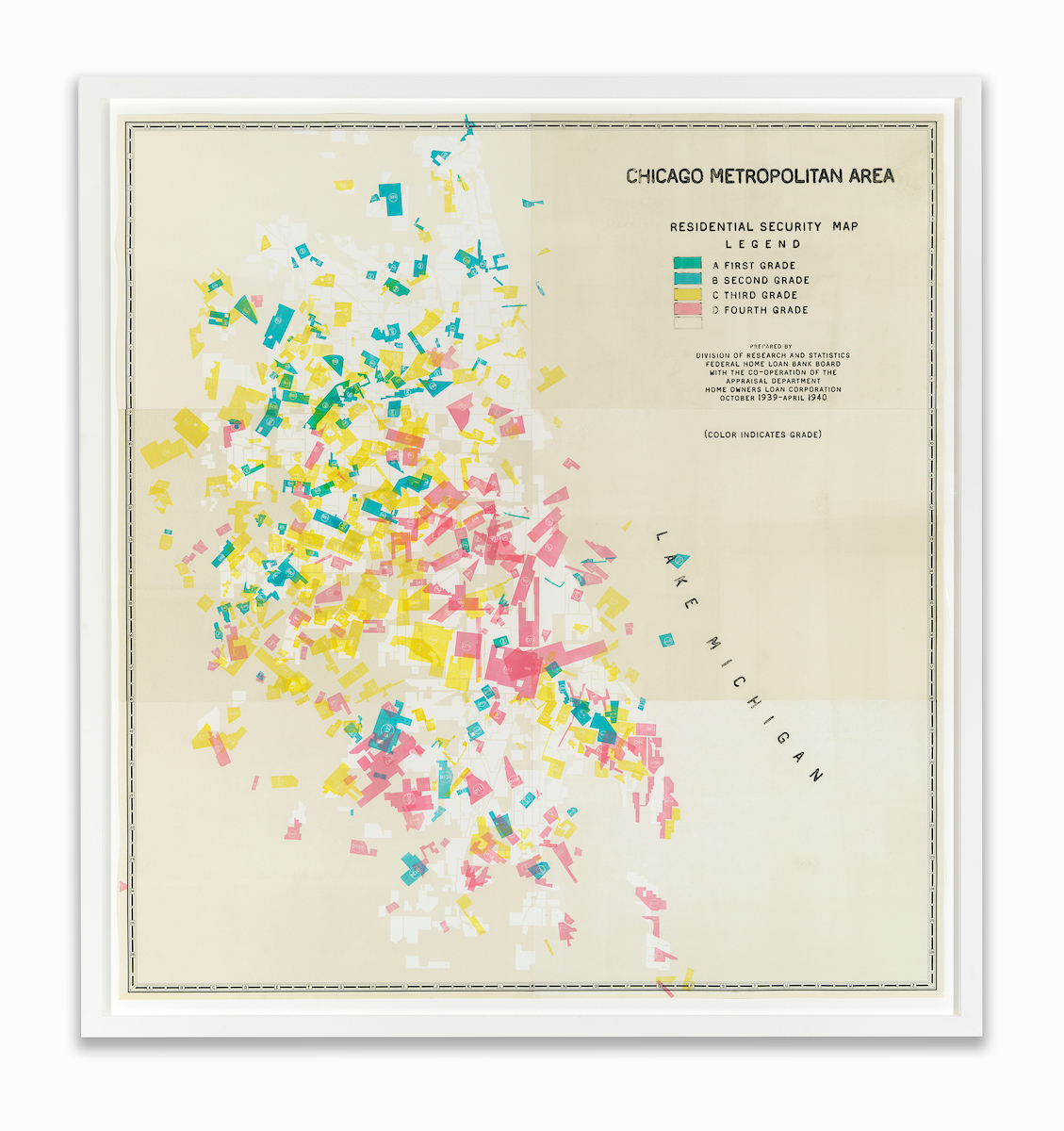
“Cadastral Shaking (Chicago V1),” 2019; Amanda Williams (b. 1974); blind debossment, screen and relief printing on archival paper, framed Edition 2 of 3, with 2 APs; Cooper Hewitt, Smithsonian Design Museum; museum purchase through the American Women’s History Initiative Acquisitions Pool, administered by the Smithsonian American Women’s History Initiative, 2021-26-1; photo: Tom VanEynde


Chicago’s neighborhoods are shaken up in this artwork by Amanda Williams. “Cadastral Shaking (Chicago v1)” reenvisions 1930s maps created by the Federal Housing Administration that were color-coded to differentiate neighborhoods where it was considered safer and more desirable to insure mortgages.

Red, which appears closer to pink here, was the color used to indicate neighborhoods that were home to African Americans—and deemed less worthy of investment. Nicknamed “redlining,” regulations like these were used to restrict where homes could be bought by African Americans, segregate communities along racial lines, and provide unequal housing opportunities to whites during the Great Depression when Americans faced severe housing shortages.

Working with Chicago’s Sputnik Press, Williams cut out each zone and shook them up to create a new map, speculating how the map might be reshaped without housing policies based on human bias.

Williams’ artwork was recently acquired by the Cooper Hewitt, Smithsonian Design Museum. It’s also included in “We Built This: How Women Innovators Shaped the World,” a new digital activity guide from the Smithsonian Education team.

arrow-up Back to top
Home
  • Facebook facebook
  • Instagram instagram
  • LinkedIn linkedin
  • YouTube youtube

  • Contact Us
  • Get Involved
  • Shop Online
  • Job Opportunities
  • Equal Opportunity
  • Inspector General
  • Records Requests
  • Accessibility
  • Host Your Event
  • Press Room
  • Privacy
  • Terms of Use